Climate Change Research ›› 2025, Vol. 21 ›› Issue (4): 519-528.doi: 10.12006/j.issn.1673-1719.2024.262
• Impacts of Climate Change • Previous Articles Next Articles
Inundation risk analysis of sea level rise in South China under SSP scenarios
WANG Chen-Xu1,2( ), JIANG Tong4(), CHEN Si-Rong3, DONG Zhi-Bo1,2, HUANG Jin-Long1,2, SU Bu-Da1,2
- 1 State Key Laboratory of Climate System Prediction and Risk Management, Nanjing University of Information Science & Technology, Nanjing 210044, China
2 School of Geographical Sciences/Institute for Disaster Risk Management, Nanjing University of Information Science & Technology, Nanjing 210044, China
3 Guangxi Climate Center, Nanning 530022, China
4 Laboratory for Climate Risk and Urban-Rural Smart Governance/School of Geographical Sciences, Jiangsu Second Normal University, Nanjing 210013, China
-
Received:2024-10-11Revised:2025-02-24Online:2025-07-30Published:2025-06-25
Cite this article
WANG Chen-Xu, JIANG Tong, CHEN Si-Rong, DONG Zhi-Bo, HUANG Jin-Long, SU Bu-Da. Inundation risk analysis of sea level rise in South China under SSP scenarios[J]. Climate Change Research, 2025, 21(4): 519-528.
share this article
Add to citation manager EndNote|Ris|BibTeX
URL: https://www.climatechange.cn/EN/10.12006/j.issn.1673-1719.2024.262
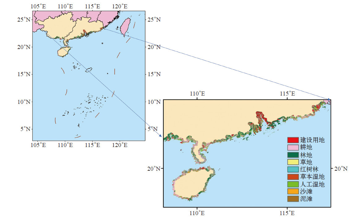
Fig. 1 Current status of land use in the coastal zone of South China
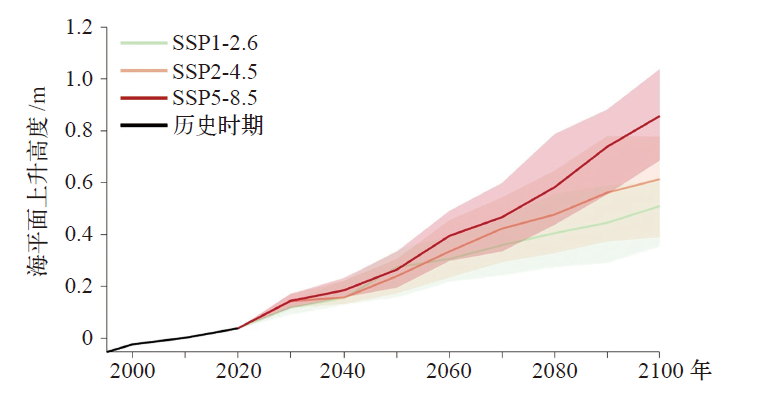
Fig. 2 Sea level rising under different SSPs in 1995-2014 (relative to 1995-2014)
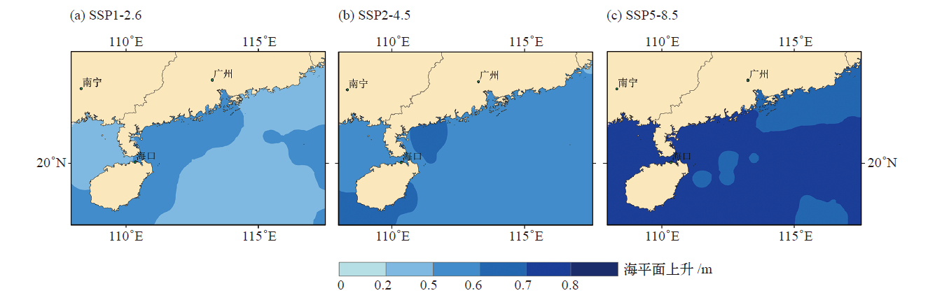
Fig. 3 Rising of sea level under different SSPs in 2080-2100 (relative to 1995-2014)
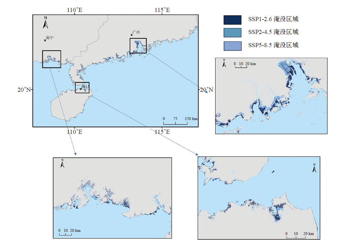
Fig. 4 Coastal inundation extent under different SSPs in 2080-2100
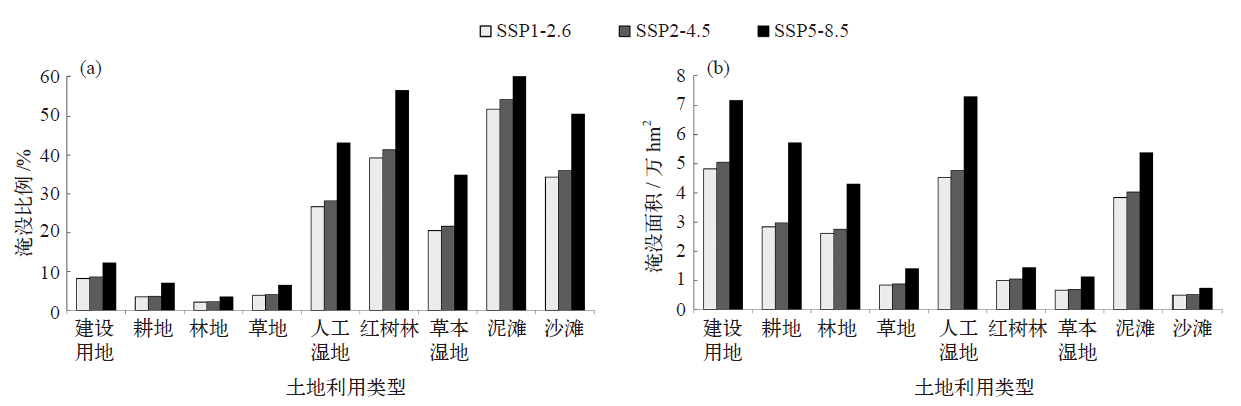
Fig. 5 Inundation ratio (a) and inundation area (b) of various land uses in the coastal zone under different SSPs in 2080-2100
| [1] | IPCC. Climate change 2022: impacts, adaptation and vulnerability[M]. Cambridge: Cambridge University Press, 2022 |
| [2] | 张通, 俞永强, 效存德, 等. IPCC AR6解读: 全球和区域海平面变化的监测和预估[J]. 气候变化研究进展, 2022, 18 (1): 12-18. |
| Zhang T, Yu Y Q, Xiao C D, et al. Interpretation of IPCC AR6 report: monitoring and projections of global and regional sea level change[J]. Climate Change Research, 2022, 18 (1): 12-18 (in Chinese) | |
| [3] | 张通, 赵励耘, 唐学远, 等. 近期国际冰盖模式比较计划回顾及启示[J]. 气候变化研究进展, 2022, 18 (4): 509-515. |
| Zhang T, Zhao L Y, Tang X Y, et al. A short review of the recent international ice sheet model intercomparison projects and its implications[J]. Climate Change Research, 2022, 18 (4): 509-515 (in Chinese) | |
| [4] | 王佳莹, 方国洪, 王永刚. 南海海面风场、高度场和温度场近十年的变化趋势及年际变化特征[J]. 海洋科学进展, 2017, 35 (2): 159-175. |
| Wang J Y, Fang G H, Wang Y G. Trends and interannual variation characteristics of wind, altitude, and temperature fields over the South China Sea over the past decade[J]. Advances in Marine Science, 2017, 35 (2): 159-175 (in Chinese) | |
| [5] |
孙艳伟, 李莹. 1993—2018年中国沿海海平面异常升高的时空格局特征及潜在社会经济风险估计[J]. 自然资源学报, 2022, 37 (4): 1073-1088.
doi: 10.31497/zrzyxb.20220417 |
| Sun Y W, Li Y. Assessment of spatio-temporal distribution characteristic of sea level anomaly changes and its potential socio-economic risks in China’s coastal areas from 1993 to 2018[J]. Journal of Natural Resources, 2022, 37 (4): 1073-1088 (in Chinese) | |
| [6] | National Oceanic and Atmospheric Administration (NOAA). 2022 sea level rise technical report. Updated projections available through 2150 for all U.S. coastal waters[R]. America: National Oceanic and Atmospheric Administration, 2022 |
| [7] | 李国胜, 扬锐. 近50年来南海海平面上升对广东沿海的影响及防治对策[J]. 中国地质灾害与防治学报, 1998 (S1): 407, 409-413. |
| Li G S, Yang R. Impact of South China Sea level rise on Guangdong coast in the past 50 years and its control measures[J]. Chinese Journal of Geological Hazard and Control, 1998 (S1): 407, 409-413 (in Chinese) | |
| [8] | 黄镇国, 张伟强, 吴厚水, 等. 珠江三角洲2030年海平面上升幅度预测及防御方略[J]. 中国科学: 地球科学, 2000 (2): 202-208. |
| Huang Z G, Zhang W Q, Wu H S, et al. Prediction of sea level rise in the Pearl River delta by 2030 and defense strategies[J]. Science China: Earth Sciences, 2000 (2): 202-208 (in Chinese) | |
| [9] | Ying Q, Svetlana J, Luke P J, et al. Coastal sea level rise around the China seas[J]. Global and Planetary Change, 2019 (172): 454-463 |
| [10] | Cheng Y C, Plag H P, D. Hamlington B, et al. Regional sea level variability in the Bohai Sea, Yellow Sea, and East China Sea[J]. Continental Shelf Research, 2015 (111): 95-107 |
| [11] | Kopp R E, Horton R M, Little C M, et al. Probabilistic 21st and 22nd century sea-level projections at a global network of tide-gauge sites[J]. Earth’s Future, 2014 (2): 383-406 |
| [12] | Kopp R E, DeConto R M, Bader D A, et al. Evolving understanding of Antarctic ice-sheet physics and ambiguity in probabilistic sea-level projections[J]. Earth’s Future, 2017 (5): 1217-1233 |
| [13] | Androulidakis Y, Makris C, Mallios Z, et al. Sea level variability and coastal inundation over the northeastern Mediterranean Sea[J]. Coastal Engineering Journal, 2023 (4): 514-545 |
| [14] |
宁荣荣, 王德, 田信鹏, 等. 黄河三角洲的地面沉降分析以及海水淹没预估[J]. 地球科学进展, 2023, 38 (3): 296-308.
doi: 10.11867/j.issn.1001-8166.2023.006 |
|
Ning R R, Wang D, Tian X P, et al. Analysis of ground settlement in the Yellow River delta and projection of seawater inundation[J]. Advances in Earth Science, 2023, 38 (3): 296-308 (in Chinese)
doi: 10.11867/j.issn.1001-8166.2023.006 |
|
| [15] |
Vousdoukas M I, Mentaschi L, Voukouvalas E, et al. Global probabilistic projections of extreme sea levels show intensification of coastal flood hazard[J]. Nature Communications, 2018, 9 (1): 2360
doi: 10.1038/s41467-018-04692-w pmid: 29915265 |
| [16] | 刘睿, 刘晓东, 刘恒. 基于CMIP5多模式集合预估东海和南海21世纪海平面高度变化[J]. 地球环境学报, 2020 (4): 412-428. |
| Liu R, Liu X D, Liu H. Projection of the 21st century sea level change in East China Sea and South China Sea based on CMIP5 model results[J]. Journal of Earth Environment, 2020 (4): 412-428 (in Chinese) | |
| [17] | 曹丽格, 方玉, 姜彤, 等. IPCC 影响评估中的社会经济新情景(SSPs)进展[J]. 气候变化研究进展, 2012, 8 (1): 74-78. |
| Cao L G, Fang Y, Jiang T, et al. Advances in shared socio-economic pathways for climate change research and assessment[J]. Climate Change Research, 2012, 8 (1): 74-78 (in Chinese) | |
| [18] | Kopp R E, Garner G G, Hermans T H, et al. A platform for characterizing parametric and structural uncertainty in future global, relative, and extreme sea-level change[J]. Geoscientific Model Development, 2023 (16): 7461-7489 |
| [19] | 王慧, 全梦媛, 徐卫青, 等. 中国沿海和近海海平面上升预测[J]. 海洋学报, 2023 (8): 1-10. |
| Wang H, Quan M Y, Xu W Q, et al. Sea level rise projection in China’s coastal and offshore areas[J]. Haiyang Xuebao, 2023 (8): 1-10 (in Chinese) | |
| [20] | Huang C J, Qiao F L. Sea level rise projection in the South China Sea from CMIP5 models[J]. Acta Oceanologica Sinica, 2015 (34): 31-41 |
| [21] | 石海莹, 吕宇波, 冯朝材. 海平面上升对海南岛沿海地区的影响[J]. 海洋开发与管理, 2018 (10): 68-71. |
| Shi H Y, Lv Y B, Feng C C. The impact of rising sea levels on the coastal areas of Hainan Island[J]. Marine Development and Management, 2018 (10): 68-71 (in Chinese) | |
| [22] | 自然资源部. 2022年中国海平面公报[R]. 北京: 自然资源部, 2023. |
| Ministry of Natural Resources of the People’s Republic of China. China sea level bulletin 2022 [R]. Beijing: Ministry of Natural Resources of the People’s Republic of China, 2023 (in Chinese) | |
| [23] | 李腾, 程晓, 刘岩, 等. CMIP6冰盖模式比较计划(ISMIP)概况与评述[J]. 气候变化研究进展, 2020, 16 (2): 255-262. |
| Li T, Cheng X, Liu Y, et al. An overview of the Ice Sheet Model Intercomparison Project (ISMIP) in CMIP 6 [J]. Climate Change Research, 2020, 16 (2): 255-262 (in Chinese) | |
| [24] | Li M, Chen B, Webster C, et al. The land-sea interface mapping: China’s coastal land covers at 10 m for 2020[J]. Science Bulletin, 2022, 67 (17): 1750-1754 |
| [25] | Hasan M F, Smith R, et al. Global land subsidence mapping reveals widespread loss of aquifer storage capacity datasets, HydroShare[DB/OL]. 2023 [2024-10-05]. https://www.hydroshare.org/resource/dc7c5bfb3a86479b889d3b30ab0e4ef7 |
| [26] | Hasan M F, Smith R, Vajedian S, et al. Global land subsidence mapping reveals widespread loss of aquifer storage capacity[J]. Nature Communications, 2023 (14): 6180 |
| [27] | 左军成, 杜凌, 陈美香, 等. 气候变化背景下海平面变化及其影响与应用[M]. 北京: 科学出版社, 2013: 270. |
| Zuo J C, Du L, Chen M X, et al. Sea level changes and their impacts and applications under the background of climate change[M]. Beijing: Science Press, 2013: 270 (in Chinese) | |
| [28] | 刘帅, 李彦究. 利用GDAL和OpenCV的海平面上升淹没模拟[J]. 测绘地理信息, 2020, 45 (4): 7-10. |
| Liu S, Li Y J. Simulation of sea level rise and inundation using GDAL and OpenCV[J]. Surveying and Mapping Geographic Information, 2020, 45 (4): 7-10 (in Chinese) | |
| [29] | 邢华桥, 侯妙乐, 王磊, 等. 基于球面QTM的海平面上升淹没模拟系统[J]. 系统仿真学报, 2015, 27 (11): 2689-2694. |
| Xing H Q, Hou M L, Wang L, et al. A simulation system for sea level rise and inundation based on spherical QTM[J]. Journal of System Simulation, 2015, 27 (11): 2689-2694 (in Chinese) | |
| [30] | 赵秀英, 王耀强, 李洪玉, 等. 基于DEM的有源淹没算法设计与实现: 以种子蔓延法为例[J]. 科技导报, 2012, 30 (8): 61-64. |
| Zhao X Y, Wang Y Q, Li H Y, et al. Design and implementation of seed spread algorithm for calculations of source flood submerge area based on DEM[J]. Science & Technology Review, 2012, 30 (8): 61-64 (in Chinese) | |
| [31] | 国家发展改革委. 全国海堤建设方案[Z]. 北京: 国家发展改革委, 2017. |
| National Development and Reform Commission. National seawall construction plan[Z]. Beijing: National Development and Reform Commission, 2017 (in Chinese) | |
| [32] | 徐慧鹏, 刘涛, 张建兵. 红树林碳埋藏过程对海平面上升、气候变化和人类活动的响应[J]. 广西科学, 2020, 27 (1): 84-90. |
| Xu H P, Liu T, Zhang J B. Response of carbon sequestration in mangroves to sea level rise, climate change and human activities[J]. Guangxi Sciences, 2020, 27 (1): 84-90 (in Chinese) | |
| [33] | Song S, Ding Y, Li W, et al. Mangrove reforestation provides greater blue carbon benefit than afforestation for mitigating global climate change[J]. Nature Communications, 2023 (14): 756 |
| [34] | Xu X, Fu D, Su F. et al. Global distribution and decline of mangrove coastal protection extends far beyond area loss[J]. Nature Communications, 2024 (15): 10267 |
| [35] | International Union for Conservation of Nature (IUCN). The IUCN red list of threatened species[R/OL]. 2024 [2024-10-05]. https://www.iucnredlist.org/en |
| [36] | International Union for Conservation of Nature (IUCN). The IUCN red list of ecosystems: red list of mangrove ecosystems[R/OL]. 2024 [2024-10-05]. https://iucn.org/resources/conservation-tool/iucn-red-list-ecosystems/red-list-mangrove-ecosystems |
| [37] | United Nations Environment Programme (UNEP). Global environment outlook GEO-6: healthy planet, healthy people[M]. Cambridge: Cambridge University Press, 2019 |
| [1] | HUA Rui-Xiang, JING Yi-Ran. Analysis of the spatio-temporal evaluation and influencing factors of inter-provincial carbon balance in China from 2000 to 2020 [J]. Climate Change Research, 2025, 21(4): 541-554. |
| [2] | CHEN Yi, CHEN Yin-Rong, CAI Hai-Sheng, CHEN Kun, LIU Min. The analysis of heterogeneity characteristics and influence intensity between land use carbon emissions and new-type urbanization in Nanchang metropolitan area [J]. Climate Change Research, 2025, 21(3): 387-399. |
| [3] | DONG Hong-Jie, DONG Wen-Jie, CAO Ying-Chun, ZHANG Yi-Fan. Inundation risk assessment of historical relics in Henan province under rainstorm scenarios based on SCS-CN model [J]. Climate Change Research, 2023, 19(6): 738-748. |
| [4] | ZHAO Li-Yun, John C. MOORE, Mike WOLOVICK. Targeted geoengineering for ice sheets [J]. Climate Change Research, 2020, 16(5): 564-569. |
| [5] | CAI Rong-Shuo,TAN Hong-Jian. Impacts and risks of accelerating sea level rise on low lying islands, coasts and communities [J]. Climate Change Research, 2020, 16(2): 163-171. |
| [6] | Ya-Qi WANG,Hai-Long LIU,Jiang-Bo JIN,Peng-Fei LIN,Jin-Feng MA,Yi-Wen LI,Zi-Peng YU,Qian YANG,Zhi-Kuo SUN,Meng-Rong DING,Yao MENG. Short commentary on CMIP6 Flux-Anomaly-Forced Model Intercomparison Project (FAFMIP) [J]. Climate Change Research, 2019, 15(5): 481-486. |
| [7] | Hui LI,Shun-Wu ZHOU,Er LU,You-Shan JIANG,Yun-Peng ZHANG. Changes in the structure of summertime precipitation in South China during 1961-2010 [J]. Climate Change Research, 2018, 14(3): 247-256. |
| [8] | Yi Si, Tan Jinkai, Li Mengya, Liang Xinxin, Wang Jun. Projection of Sea Level Rise and Its Impacts on Coastal Wetlands Within the Yangtze Estuary [J]. Climate Change Research, 2017, 13(6): 598-605. |
| [9] | Zhang Lei, Ren Guoyu, Baoleerqimuge, Xu Bin, Yu Jingjing. Climatology and Change of the South China Sea Surface Temperature Based on Satellite Observations [J]. Climate Change Research, 2017, 13(3): 189-197. |
| [10] | Zhong Quanjia, Zhang Lifeng, Ding Ruiqiang, Qin Jianhuang. The Variation of Summer Precipitation in South China and Its Relationship with SST Anomalies in the Tropical Pacific [J]. Climate Change Research, 2016, 12(1): 28-36. |
| [11] | Cheng Heqin, Ta Na, Zhou Ying, Zhu Jianrong, Ruan Renliang, Chen Jiyu. Risk Assessment and Adaptation of Fresh Water Supply in the Changjiang Estuary Impacted by Sea Level Rise in the Shanghai City [J]. Climate Change Research, 2015, 11(4): 263-269. |
| [12] | Cheng Heqin, Wang Dongmei, Chen Jiyu. Study and Prediction of the Relative Sea Level Rise in 2030 in Shanghai Area [J]. Climate Change Research, 2015, 11(4): 231-238. |
| [13] | Chen Zujun, Shi Xiaowen, Mao Xinghua. Study on Impacts of Sea Level Rising in the Changjiang Estuary on Waterlogging-Controlling Safety of Chongming County [J]. Climate Change Research, 2015, 11(4): 239-244. |
| [14] | Zhu Jianhua, Feng Yuan, Zeng Lixiong, Huang Zhilin, Xiao Wenfa. The Methodology of Provincial Greenhouse Gases Inventory in Land Use Change and Forestry Sector [J]. Climate Change Research, 2014, 10(6): 433-439. |
| [15] | Hua Wenjian, Chen Haishan. Impacts of Regional-Scale Land Use/ Land Cover Change on Diurnal Temperature Range [J]. Climate Change Research, 2013, 9(2): 117-122. |
| Viewed | ||||||
|
Full text |
|
|||||
|
Abstract |
|
|||||