Climate Change Research ›› 2025, Vol. 21 ›› Issue (6): 766-776.doi: 10.12006/j.issn.1673-1719.2025.056
• Impacts of Climate Change • Previous Articles Next Articles
Projection of the suitable cultivation area for single-cropping rice in the Jianghuai region based on CMIP6 and MaxEnt model
WANG Sheng1,5( ), CHEN Jian2, ZHOU Yu3, SUN Jia-Li4, ZHAI Zhen-Fang2, XIE Wu-San1, DAI Juan1, DING Xiao-Jun1, WU Rong1
- 1 Anhui Climate Centre, Hefei 230031, China
2 Hefei Meteorological Observatory, Hefei 230041, China
3 Shanghai Climate Centre, Shanghai 200030, China
4 Jiangsu Climate Centre, Nanjing 210019, China
5 Huaihe River Basin Meteorological Centre, Hefei 230031, China
-
Received:2025-03-14Revised:2025-05-31Online:2025-11-30Published:2025-11-11
Cite this article
WANG Sheng, CHEN Jian, ZHOU Yu, SUN Jia-Li, ZHAI Zhen-Fang, XIE Wu-San, DAI Juan, DING Xiao-Jun, WU Rong. Projection of the suitable cultivation area for single-cropping rice in the Jianghuai region based on CMIP6 and MaxEnt model[J]. Climate Change Research, 2025, 21(6): 766-776.
share this article
Add to citation manager EndNote|Ris|BibTeX
URL: https://www.climatechange.cn/EN/10.12006/j.issn.1673-1719.2025.056
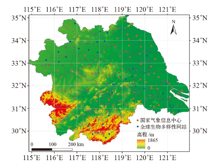
Fig. 1 Potential distribution of single-cropping rice planting areas in the Jianghuai region
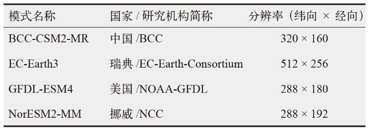 |
Table 1 CMIP6 climate models used in this study
| |
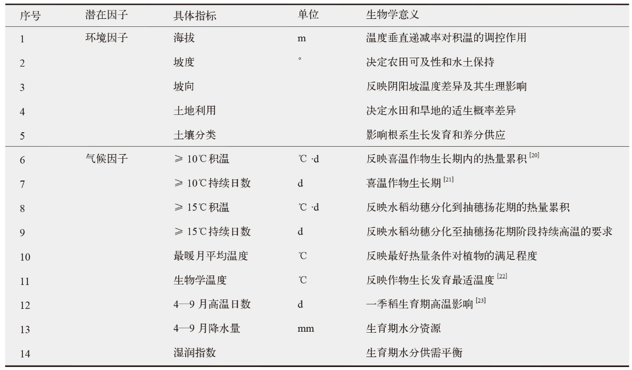 |
Table 2 Potential impact factors for the distribution of single-cropping rice planting in the Jianghuai region
| |
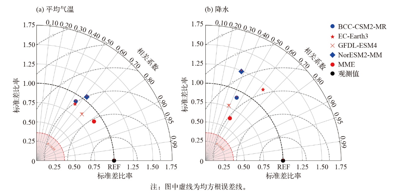
Fig. 2 Taylor diagram of the mean temperature (a) and precipitation (b) during April-September simulated by CMIP6 climate models compared with observations
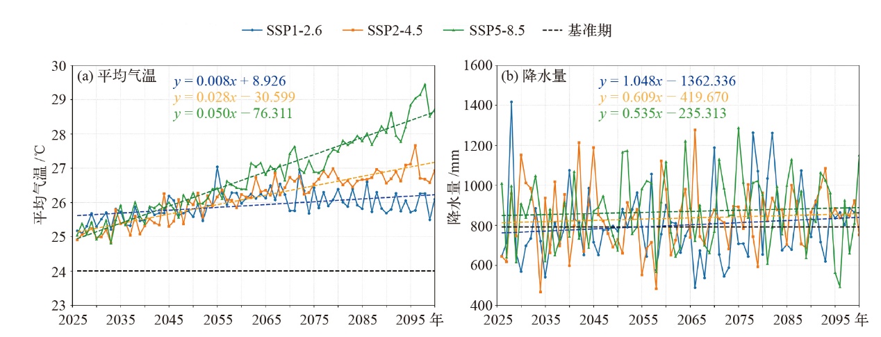
Fig. 3 Projected changes in mean temperature (a) and precipitation (b) during the entire growth period of single-cropping rice under different SSPs scenarios from 2026 to 2100
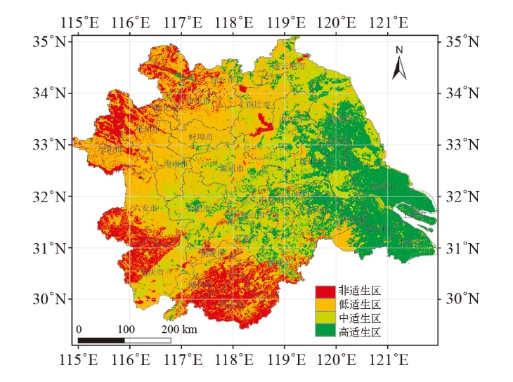
Fig. 4 Potential distribution pattern of single-cropping rice planting in the Jianghuai region during the baseline period of model hindcasting
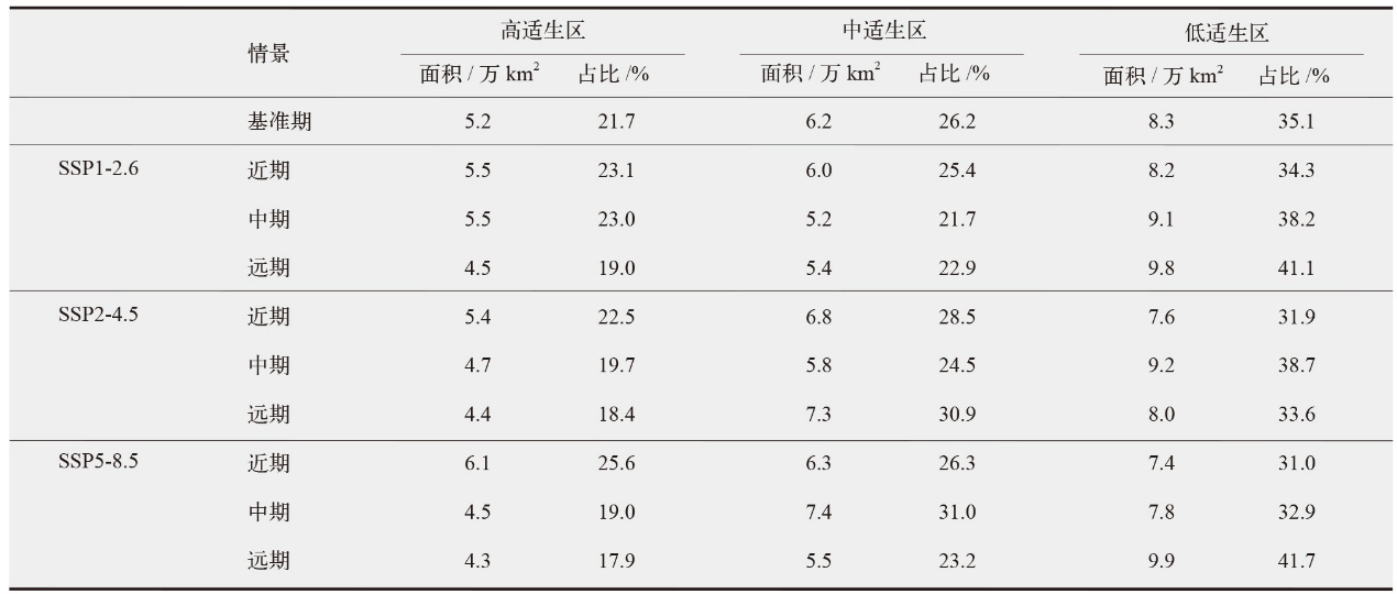 |
Table 3 Proportion of suitable area for single-cropping rice during the baseline period and future scenarios
| |
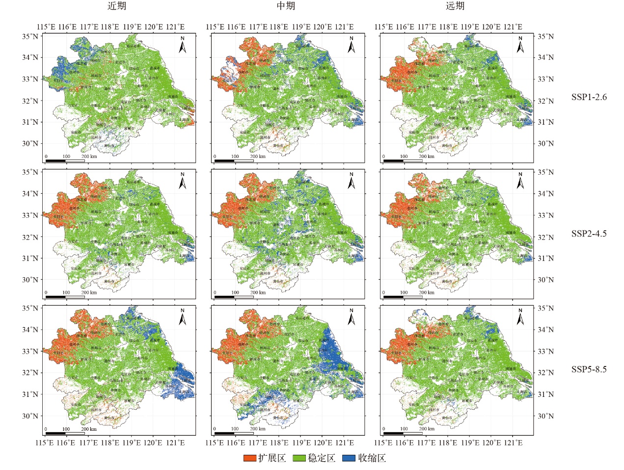
Fig. 5 Comparison of the potential spatial distribution pattern changes of single-cropping rice planting in 2026-2040, 2041-2070, and 2071-2100 relative to the baseline period
 |
Table 4 Changes in high-temperature days and extreme temperature probability in southern Jiangsu (south of 32°N) under SSP5-8.5
| |
| [1] | IPCC. Climate change 2021: the physical science basis[M]. Cambridge: Cambridge University Press, 2021 |
| [2] | Sun X B, Tian Q, Long L, et al. Influence of temperature and sunlight on growth and yield of rice in different growth stages in Xuancheng area[J]. Chinese Agricultural Science Bulletin, 2016, 32 (27): 1-6 |
| [3] |
Lobell D, Schlenker W, Costa-Roberts J. Climate trends and global crop production since 1980[J]. Science, 2011, 333 (6042): 616-620
doi: 10.1126/science.1204531 pmid: 21551030 |
| [4] |
段居琦, 周广胜. 中国双季稻种植区的气候适宜性研究[J]. 中国农业科学, 2012, 45 (2): 218-227.
doi: 10.3864/j.issn.0578-1752.2012.02.003 |
| Duan J Q, Zhou G S. Climatic suitability of double rice planting regions in China[J]. Scientia Agricultura Sinica, 2012, 45 (2): 218-227 (in Chinese) | |
| [5] | 马润佳. 我国作物主要种植区气候生产潜力及种植适宜性分析[D]. 南京: 南京信息工程大学, 2017. |
| Ma R J. Climate potential and planting suitability analysis of major crop growing areas in China[D]. Nanjing: Nanjing University of Information Science and Technology, 2017 (in Chinese) | |
| [6] | Zhang Y J, Wang Y F, Niu H S. Spatio-temporal variations in the areas suitable for the cultivation of rice and maize in China under future climate scenarios[J]. Science of the Total Environment, 2017 (601-602): 518-531 |
| [7] |
Phillips S J, Anderson R P, Schapire R E. Maximum entropy modeling of species geographic distributions[J]. Ecological Modelling, 2006, 190 (3-4): 231-259
doi: 10.1016/j.ecolmodel.2005.03.026 URL |
| [8] | 吕彤, 郭倩, 丁永霞, 等. 基于MaxEnt模型预测未来气候变化情景下中国区域水稻潜在适生区的变化[J]. 中国农业气象, 2022, 43 (4): 262-275. |
| Lv T, Guo Q, Ding Y X, et al. Predicting potential suitable planting area of rice in China under future climate change scenarios using the MaxEnt model[J]. Chinese Journal of Agrometeorology, 2022, 43 (4): 262-275 (in Chinese) | |
| [9] |
Liu B, Huang L, Jiang X, et al. Quantitative evaluation and mechanism analysis of soil chemical factors affecting rice yield in saline-sodic paddy field[J]. Agricultural Water Management, 2023, 289: 108523
doi: 10.1016/j.agwat.2023.108523 URL |
| [10] | 王胜, 许红梅, 王德燕, 等. 基于CMIP5模式安徽省植被净初级生产力预估[J]. 气候变化研究进展, 2018, 14 (3): 266-274. |
| Wang S, Xu H M, Wang D Y, et al. Projection of vegetation net primary productivity based on CMIP5 models in Anhui province[J]. Climate Change Research, 2018, 14 (3): 266-274 (in Chinese) | |
| [11] | 蒋文好, 陈活泼. CMIP6模式对亚洲中高纬区极端温度变化的模拟及预估[J]. 大气科学学报, 2021, 44 (4): 592-603. |
| Jiang W H, Chen H P. Assessment and projection of changes in temperature extremes over the mid-high latitudes of Asia based on CMIP6 models[J]. Transactions of Atmospheric Sciences, 2021, 44 (4): 592-603 (in Chinese) | |
| [12] |
Liu L L, Xu H M, Wang Y, et al. Impacts of 1.5 and 2℃ global warming on water availability and extreme hydrological events in Yiluo and Beijiang River catchments in China[J]. Climatic Change, 2017, 145 (10): 1-14
doi: 10.1007/s10584-017-2067-0 URL |
| [13] |
Zhang L, Zhu L, Li Y, et al. Maxent modelling predicts a shift in suitable habitats of a subtropical evergreen tree (Cyclobalanopsis glauca (Thunberg) Oersted) under climate change scenarios in China[J]. Forests, 2022, 13 (1): 126
doi: 10.3390/f13010126 URL |
| [14] |
Zhu H, Jiang Z, Li L. Projection of climate extremes in China, an incremental exercise from CMIP5 to CMIP6[J]. Science Bulletin, 2021, 66: 2528-2537
doi: 10.1016/j.scib.2021.07.026 pmid: 36654212 |
| [15] | Zhu H, Jiang Z, Li J, et al. Does CMIP6 inspire more confidence in simulating climate extremes over China?[J]. Advance in Atmospheric Sciences, 2020, 37 (10): 1119-1132 |
| [16] |
Zhang S B, Chen J. Uncertainty in projection of climate extremes: a comparison of CMIP5 and CMIP6[J]. Journal of Meteorological Research, 2021, 35 (4): 646-662
doi: 10.1007/s13351-021-1012-3 |
| [17] | Kumar S, Stohlgren T J. Maxent modeling for predicting suitable habitat for threatened and endangered tree Canacomyrica monticola in New Caledonia[J]. Journal of Ecology & The Natural Environment, 2009, 1 (4): 94-98 |
| [18] |
Hempel S, Frieler K, Warszawski L, et al. A trend-preserving bias correction the ISI-MIP approach[J]. Earth System Dynamics, 2013, 4 (2): 219-236
doi: 10.5194/esd-4-219-2013 URL |
| [19] | Vetter V, Huang S, Aich V, et al. Multi-model climate impact assessment and intercomparison for three large-scale river basins on three continents[J]. Earth System Dynamics, 2014, 5 (2): 849-900 |
| [20] | 全国种植制度气候研究南方协作组. 我国南方稻区种植制度的气候区划[J]. 中国农业科学, 1982, 15 (4): 35-42. |
| Associate Research Group for Agroclimatological Study of Cropping System in South China. Regionalization of cropping systems in rice growing regions in South China[J]. Scientia Agricultura Sinica, 1982, 15 (4): 35-42 (in Chinese) | |
| [21] | 中国水稻研究所. 中国水稻种植区划[M]. 杭州: 浙江科技出版社, 1989. |
| China National Rice Research Institute. Rice cropping regionalization in China[M]. Hangzhou: Zhejiang Science and Technology Press, 1989 (in Chinese) | |
| [22] | 周广胜, 王玉辉. 全球生态学[M]. 北京: 气象出版社, 2003. |
| Zhou G S, Wang Y H. Global ecology[M]. Beijing: China Meteorological Press, 2003 (in Chinese) | |
| [23] | 朱世峰, 王卫光, 丁一民, 等. 基于CMIP6的长江中下游未来水稻高温热害时空变化特征[J]. 农业工程学报, 2023, 39 (3): 113-122. |
| Zhu S F, Wang W G, Ding Y M, et al. Spatiotemporal variation of future heat damage of rice in the middle and lower reaches of the Yangtze River using CMIP6 projections[J]. Transactions of the Chinese Society of Agricultural Engineering, 2023, 39 (3): 113-122 (in Chinese) | |
| [24] |
翁恩生, 周广胜. 用于全球变化研究的中国植物功能型划分[J]. 植物生态学报, 2005, 29 (1): 81-97.
doi: 10.17521/cjpe.2005.0012 |
|
Weng E S, Zhou G S. Defining plant functional types in China for global change studies[J]. Chinese Journal of Plant Ecology, 2005, 29 (1): 81-97 (in Chinese)
doi: 10.17521/cjpe.2005.0012 URL |
|
| [25] |
Kumar A, Kumar A, Adhikari D, et al. Ecological niche modeling for assessing potential distribution of Pterocarpus marsupium Roxb. in Ranchi, eastern India[J]. Ecological Research, 2020, 35 (6): 1095-1105
doi: 10.1111/1440-1703.12176 |
| [26] | 应邦肯, 田阔, 郭浩宇, 等. 基于MaxEnt模型预测未来气候变化情境下红树秋茄在中国潜在适生区的变化[J]. 生态学报, 2024, 44 (1): 224-234. |
| Ying B K, Tian K, Guo H Y, et al. Predicting potential suitable habitats of Kandelia obovata in China under future climatic scenarios based on MaxEnt model[J]. Acta Ecologica Sinica, 2024, 44 (1): 224-234 (in Chinese) | |
| [27] |
Swets K A. Measuring the accuracy of diagnostic systems[J]. Science, 1988, 240 (4857): 1285-1293
doi: 10.1126/science.3287615 pmid: 3287615 |
| [28] |
Taylor K E. Summarizing multiple aspects of model performance in a single diagram[J]. Journal of Geophysical Research, 2001, 106 (7): 7183-7192
doi: 10.1029/2000JD900719 URL |
| [29] | 张丽霞, 陈晓龙, 辛晓歌. CMIP6情景模式比较计划 (ScenarioMIP) 概况与评述[J]. 气候变化研究进展, 2019, 15 (5): 519-525. |
| Zhang L X, Chen X L, Xin X G. Short commentary on CMIP6 Scenario Model Intercomparison Project (ScenarioMIP)[J]. Climate Change Research, 2019, 15 (5): 519-525 (in Chinese) | |
| [30] |
杨明鑫, 肖天贵, 李勇, 等. CMIP6模式对我国西南地区夏季气候变化的模拟和预估[J]. 高原气象, 2022, 41 (6): 1557-1571.
doi: 10.7522/j.issn.1000-0534.2021.00119 |
|
Yang M X, Xiao T G, Li Y, et al. Evaluation and projection of climate change in Southwest China using CMIP6 models[J]. Plateau Meteorology, 2022, 41 (6): 1557-1571 (in Chinese)
doi: 10.7522/j.issn.1000-0534.2021.00119 |
| [1] | SHI Ying, XU Ying, CHAO Qing-Chen, ZHANG Meng-Ran, HAN Zhen-Yu, WANG Rong. Climate change projection over the west route of the South-to-North Water Transfer Project based on CMIP6 global climate models [J]. Climate Change Research, 2025, 21(3): 340-352. |
| [2] | ZHU Guang-Xi, XIAO Cun-De, CHEN Bo, ZHAO Ying-Dong. Spring snowmelt flood estimate in the upper Heihe River under climate change [J]. Climate Change Research, 2020, 16(6): 667-678. |
| [3] | Qi-Mou ZHANG,Run WANG,Tong JIANG,Song-Sheng CHEN. Projection of extreme precipitation in the Hanjiang River basin under different RCP scenarios [J]. Climate Change Research, 2020, 16(3): 276-286. |
| [4] | Zhang Dongfeng, Han Zhenyu, Shi Ying. Comparison of Climate Projection Between the Driving CSIRO-Mk3.6.0 and the Downscaling Simulation of RegCM4.4 over China [J]. Climate Change Research, 2017, 13(6): 557-568. |
| [5] | . Projected Climate Change over China Under SRES A1B Scenario: Multi-model Ensemble and Uncertainties [J]. Climate Change Research, 2010, 6(04): 270-276. |
| [6] | Xiaofan Zeng;Su Buda;Bi-wen WU. Projected Stream Flow in the Huaihe River in 2010-2100 [J]. Climate Change Research, 2010, 6(01): 15-21. |
| Viewed | ||||||
|
Full text |
|
|||||
|
Abstract |
|
|||||