气候变化研究进展 ›› 2022, Vol. 18 ›› Issue (3): 343-354.doi: 10.12006/j.issn.1673-1719.2021.250
中巴经济走廊极端低温事件风险评估
李涛1,2( ), 陶辉1(), 陈金雨1,2
- 1 中国科学院新疆生态与地理研究所荒漠与绿洲生态国家重点实验室,乌鲁木齐 830011
2 中国科学院大学,北京 100049
-
收稿日期:2021-10-25修回日期:2021-11-10出版日期:2022-05-30发布日期:2022-04-20 -
通讯作者:陶辉 -
作者简介:李涛,男,硕士研究生,litao202@mails.ucas.ac.cn 。 -
基金资助:科技部基础资源调查专项(2018FY100501);中国科学院西部之光项目(2019-XBQNXZ-B-004);中国科学院西部之光项目(2019-XBYJRC-001)
Risk assessment of extreme low temperature events over the China-Pakistan Economic Corridor
LI Tao1,2(), TAO Hui1(), CHEN Jin-Yu1,2
- 1 State Key Laboratory of Desert and Oasis Ecology, Xinjiang Institute of Ecology and Geography, Chinese Academy of Sciences, Urumqi 830011, China
2 University of Chinese Academy of Science, Beijing 100049, China
-
Received:2021-10-25Revised:2021-11-10Online:2022-05-30Published:2022-04-20 -
Contact:TAO Hui
摘要:
危险性、暴露度、脆弱性是极端低温事件风险评估的关键因素。基于1961—2015年中巴经济走廊地区逐日最低气温、人口和耕地等数据,选取极端低温事件强度、频次、持续时间,人口密度,耕地面积占比,植被覆盖度,数字高程模型(DEM),脆弱人口比重和性别比重9个指标,采用层次分析法和熵权法确定各指标组合权重,对中巴经济走廊地区极端低温事件进行风险评估,实现了中巴经济走廊极端低温事件不同风险等级(低、较低、中、较高、高风险)的区划。研究表明,中巴经济走廊内极端低温事件风险分布具有显著的空间差异,极端低温事件风险受极端低温事件强度、人口密度和地形影响较大。区域内绝大部分地区属于低风险地区,高风险地区有巴基斯坦的阿扎德克什米尔地区、吉尔吉特-巴尔蒂斯坦地区、开普省地区、联邦直辖部落地区和中国的喀什地区。其中,阿扎德克什米尔高风险面积占比最高(约35%),联邦直辖部落地区较高风险面积占比最高(约7.7%),吉尔吉特-巴尔蒂斯坦地区中风险地区面积占比最高(约24.6%);中风险地区占比超过10%的还有开普省(12.5%)、阿扎德克什米尔(20%)、联邦直辖部落地区(10.2%)、中国喀什地区(14.3%)。评估结果与历史灾情吻合,可为区域气象灾害风险评估和防灾减灾提供参考。
引用本文
李涛, 陶辉, 陈金雨. 中巴经济走廊极端低温事件风险评估[J]. 气候变化研究进展, 2022, 18(3): 343-354.
LI Tao, TAO Hui, CHEN Jin-Yu. Risk assessment of extreme low temperature events over the China-Pakistan Economic Corridor[J]. Climate Change Research, 2022, 18(3): 343-354.
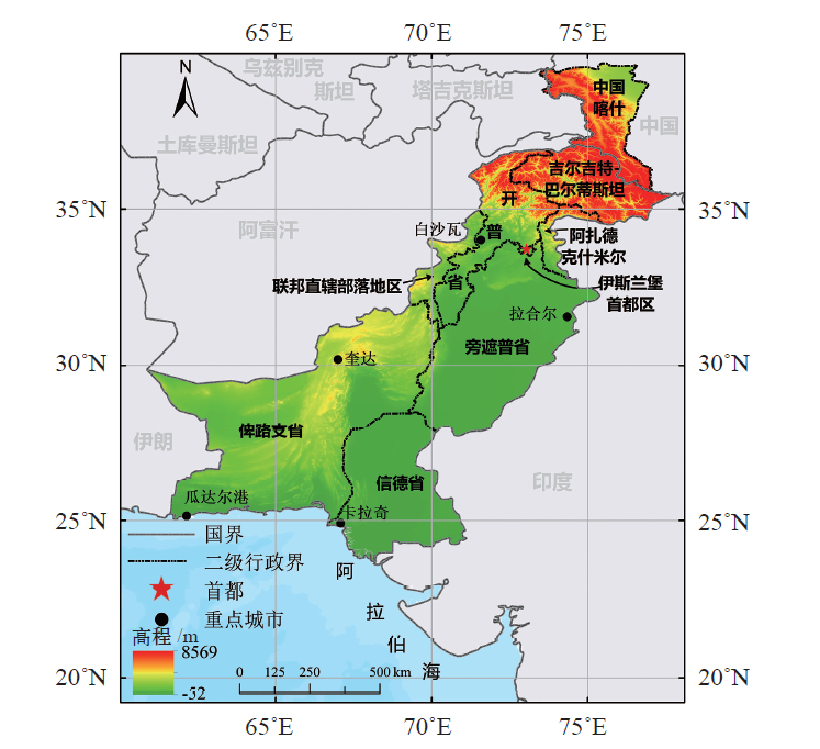
图1 中巴经济走廊地区地理位置
Fig. 1 Geographical location of China-Pakistan Economic Corridor (CPEC)
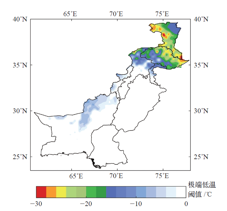
图2 中巴经济走廊极端低温阈值空间分布
Fig. 2 Spatial distribution of extreme low temperature thresholds in CPEC
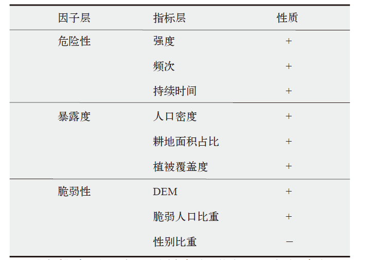 |
表1 极端低温事件风险评估指数的指标体系
Table 1 Risk index system of extreme low temperature events
| |
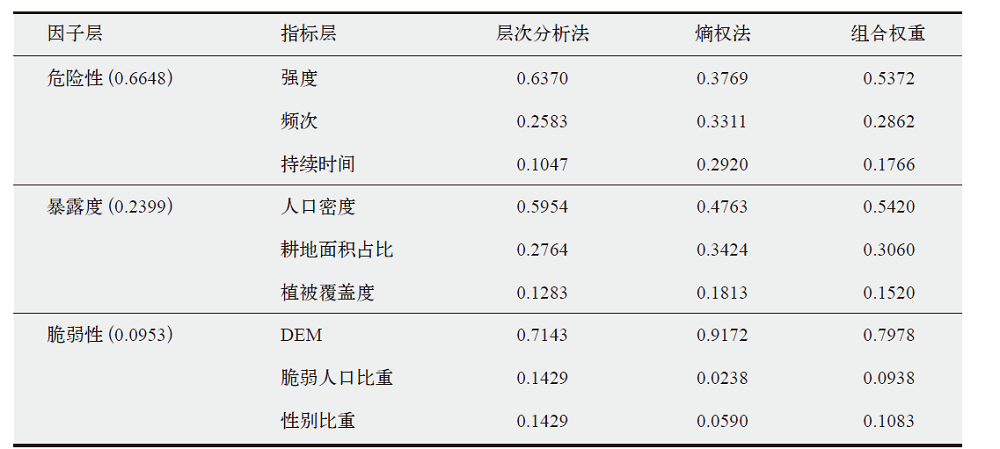 |
表2 极端低温事件风险指标权重
Table 2 Weight of extreme low temperature event risk index
| |
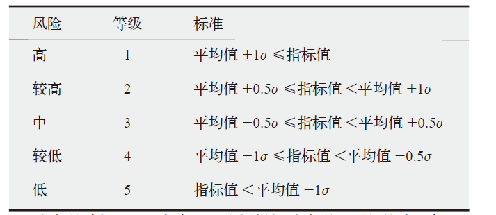 |
表3 极端低温事件风险评估分级标准
Table 3 Classification standard of extreme low temperature event risk assessment
| |

图3 中巴经济走廊危险性指数空间分布
Fig. 3 Spatial distribution of hazard index of CPEC
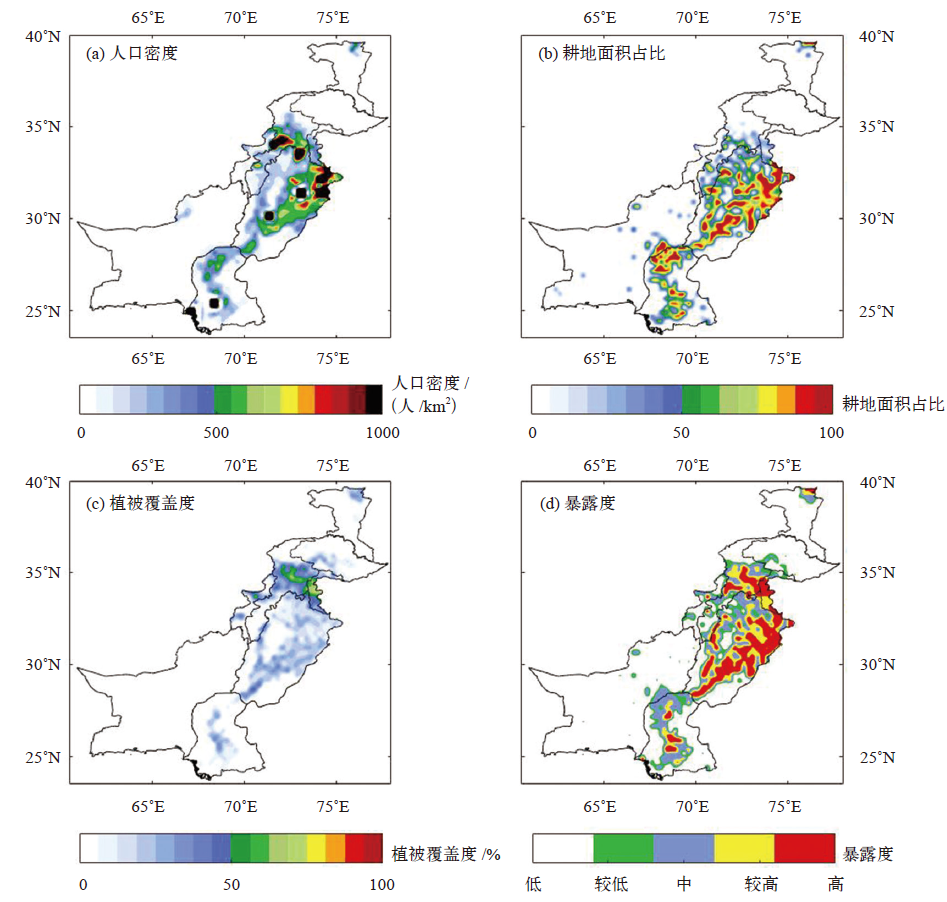
图4 中巴经济走廊暴露度指数空间分布
Fig. 4 Spatial distribution of exposure index of CPEC
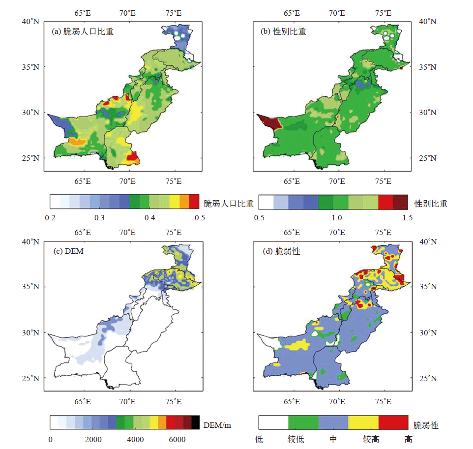
图5 中巴经济走廊脆弱性指数空间分布
Fig. 5 Spatial distribution of vulnerability index of CPEC
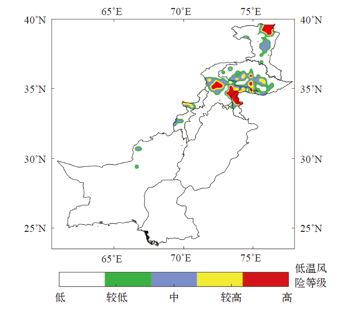
图6 中巴经济走廊极端低温风险等级空间分布
Fig. 6 Spatial distribution of extreme low temperature risk in CPEC

图7 中巴经济走廊及各行政单元极端低温事件不同风险区所占面积比例
Fig. 7 Area proportion of extreme low temperature events at different risk levels for different administrative units in CPEC
| [1] | IPCC. Climate change 2021: the physical science basis[M]. Cambridge: Cambridge University Press, 2021 |
| [2] |
Gasparrini A, Guo Y M, Hashizume M, et al. Mortality risk attributable to high and low ambient temperature: a multicountry observational study[J]. Lancet, 2015, 386 (9991): 369-375
doi: 10.1016/S0140-6736(14)62114-0 pmid: 26003380 |
| [3] |
Pal J S, Eltahir E A B. Future temperature in Southwest Asia projected to exceed a threshold for human adaptability[J]. Nature Climate Change, 2016, 6 (2): 197-200
doi: 10.1038/nclimate2833 URL |
| [4] |
Hasegawa T, Sakurai G, Fujmori S, et al. Extreme climate events increase risk of global food insecurity and adaptation needs[J]. Nature Food, 2021, 2 (8): 587-595
doi: 10.1038/s43016-021-00335-4 URL |
| [5] |
Palmer T. Record-breaking winters and global climate change[J]. Science, 2014, 344 (6186): 803-804
doi: 10.1126/science.1255147 pmid: 24855240 |
| [6] |
Lesk C, Rowhani P, Ramankutty N. Influence of extreme weather disasters on global crop production[J]. Nature, 2016, 529 (7584): 84-87
doi: 10.1038/nature16467 URL |
| [7] | 朱红蕊, 刘赫男, 张洪玲, 等. 黑龙江省玉米低温冷害风险评估及预估[J]. 气候变化研究进展, 2015, 11 (3): 173-178. |
| Zhu H R, Liu H N, Zhang H L, et al. Evaluation and projection of maize cold damage in Heilongjiang[J]. Climate Change Research, 2015, 11 (3): 173-178 (in Chinese) | |
| [8] | 丁一汇, 王遵娅, 宋亚芳, 等. 中国南方2008年1月罕见低温雨雪冰冻灾害发生的原因及其与气候变暖的关系[J]. 气象学报, 2008 (5): 808-825. |
| Ding Y H, Wang Z Y, Song Y F, et al. Causes of the unprecedented freezing disaster in January 2008 and its possible association with the global warming[J]. Acta Meteorologica Sinica, 2008 (5): 808-825 (in Chinese) | |
| [9] | 王维国, 缪宇鹏, 孙瑾. 欧亚极端寒冷事件分析及灾害应对措施[J]. 中国应急管理, 2012 (3): 52-55. |
| Wang W G, Miao Y P, Sun J. Analysis of extreme cold events in Eurasia and disaster response measures[J]. China Emergency Management, 2012 (3): 52-55 (in Chinese) | |
| [10] |
Bellprat O, Guemas V, Doblas-reyes F, et al. Towards reliable extreme weather and climate event attribution[J]. Nature Communications, 2019, 10 (1): 1732
doi: 10.1038/s41467-019-09729-2 pmid: 30988387 |
| [11] |
Fischer E M, Sippel S, Knutti R. Increasing probability of record-shattering climate extremes[J]. Nature Climate Change, 2021, 11 (8): 689-695
doi: 10.1038/s41558-021-01092-9 URL |
| [12] |
Lauretano V, Kennedy-asser A T, Korasidis V A, et al. Eocene to Oligocene terrestrial Southern Hemisphere cooling caused by declining pCO2[J]. Nature Geoscience, 2021, 14: 659-664
doi: 10.1038/s41561-021-00788-z URL |
| [13] |
Cai W, Wang G, Santoso A, et al. Increased frequency of extreme La Niña events under greenhouse warming[J]. Nature Climate Change, 2015, 5 (2): 132-137
doi: 10.1038/nclimate2492 URL |
| [14] | Brown A. Mean and extreme snowfall[J]. Nature Climate Change, 2014, 4 (10): 860 |
| [15] | 王安乾, 苏布达, 王艳君, 等. 中国极端低温事件特征及其耕地暴露度研究[J]. 资源科学, 2017, 39 (5): 954-963. |
| Wang A Q, Su B D, Wang Y J, et al. The characteristics of extreme minimum temperature events and exposure of farmland in China[J]. Resources Science, 2017, 39 (5): 954-963 (in Chinese) | |
| [16] |
Oudin A D, Forsberg B, Ebi K L, et al. Attributing mortality from extreme temperatures to climate change in Stockholm, Sweden[J]. Nature Climate Change, 2013, 3 (12): 1050-1054
doi: 10.1038/nclimate2022 URL |
| [17] | 李言蹊, 陈海山. 冬季亚洲中纬度极端低温事件与巴伦支-喀拉海异常增暖的关系及联系机制[J]. 大气科学, 2021, 45 (4): 889-900. |
| Li Y X, Chen H S. The relationship between winter extremely low temperature events in mid-latitude Asia and abnormal warming over Barents-Kara Seas and associated mechanism[J]. Chinese Journal of Atmospheric Sciences, 2021, 45 (4): 889-900 (in Chinese) | |
| [18] |
Ali S, Eum H I, Cho J, et al. Assessment of climate extremes in future projections downscaled by multiple statistical downscaling methods over Pakistan[J]. Atmospheric Research, 2019, 222: 114-133
doi: 10.1016/j.atmosres.2019.02.009 URL |
| [19] |
Ullah S, You Q L, Ullah W, et al. Observed changes in temperature extremes over China-Pakistan Economic Corridor during 1980-2016[J]. International Journal of Climatology, 2019, 39 (3): 1457-1475
doi: 10.1002/joc.5894 URL |
| [20] |
Khan N, Shahid S, Bin I T, et al. Spatial distribution of unidirectional trends in temperature and temperature extremes in Pakistan[J]. Theoretical and Applied Climatology, 2019, 136 (3-4): 899-913
doi: 10.1007/s00704-018-2520-7 URL |
| [21] | 李涛, 陶辉, 陈金雨. 1961-2015年中巴经济走廊极端低温事件数据集[J]. 中国科学数据, 2021, 6 (4): 33-42. |
| Li T, Tao H, Chen J Y. A gridded dataset of extremely low-temperature events in the China-Pakistan Economic Corridor during 1961-2015[J]. China Scientific Data, 2021, 6 (4): 33-42 (in Chinese) | |
| [22] |
Ullah S, You Q, Ali A, et al. Observed changes in maximum and minimum temperatures over China-Pakistan Economic Corridor during 1980-2016[J]. Atmospheric Research, 2019, 216: 37-51
doi: 10.1016/j.atmosres.2018.09.020 |
| [23] | 尹姗, 孙诚, 李建平. 灾害风险的决定因素及其管理[J]. 气候变化研究进展, 2012, 8 (2): 84-89. |
| Yin S, Sun C, Li J P. Determinants of disaster risk and disaster risk management[J]. Climate Change Research, 2012, 8 (2): 84-89 (in Chinese) | |
| [24] |
Murnane R J, Allegri G, Bushi A, et al. Data schemas for multiple hazards, exposure and vulnerability[J]. Disaster Prevention and Management: An International Journal, 2019, 28 (6): 752-763
doi: 10.1108/DPM-09-2019-0293 URL |
| [25] |
Chen Y, Moufouma-okia W, Masson-delmotte V, et al. Recent progress and emerging topics on weather and climate extremes since the Fifth Assessment Report of the Intergovernmental Panel on Climate Change[J]. Annual Review of Environment and Resources, 2018, 43: 35-59
doi: 10.1146/annurev-environ-102017-030052 URL |
| [26] |
杨晓静, 徐宗学, 左德鹏, 等. 东北三省农业旱灾风险评估研究[J]. 地理学报, 2018, 73 (7): 1324-1337.
doi: 10.11821/dlxb201807011 |
| Yang X J, Xu Z X, Zuo D P, et al. Assessment on the risk of agricultural drought disaster in the three provinces of Northeast China[J]. Acta Geographica Sinica, 2018, 73 (7): 1324-1337 (in Chinese) | |
| [27] |
尹占娥, 田鹏飞, 迟潇潇. 基于情景的1951-2011年中国极端降水风险评估[J]. 地理学报, 2018, 73 (3): 405-413.
doi: 10.11821/dlxb201803002 |
| Yin Z E, Tian P F, Chi X X. Multi-scenario-based risk analysis of precipitation extremes in China during the past 60 years (1951-2011)[J]. Acta Geographica Sinica, 2018, 73 (3): 405-413 (in Chinese) | |
| [28] | 吕嫣冉, 姜彤, 陶辉, 等. “一带一路”区域极端高温事件与人口暴露度特征[J]. 科技导报, 2020, 38 (16): 68-79. |
| Lv Y R, Jiang T, Tao H, et al. Spatial-temporal patterns of population exposed to the extreme maximum temperature events in the Belt and Road regions[J]. Science & Technology Review, 2020, 38 (16): 68-79 (in Chinese) | |
| [29] | 吴绍洪, 潘韬, 贺山峰. 气候变化风险研究的初步探讨[J]. 气候变化研究进展, 2011, 7 (5): 363-368. |
| Wu S H, Pan T, He S F. Primary study on the theories and methods of research on climate change risk[J]. Climate Change Research, 2011, 7 (5): 363-368 (in Chinese) | |
| [30] | 王安乾, 苏布达, 王艳君, 等. 全球升温1.5℃与2.0℃情景下中国极端低温事件变化与耕地暴露度研究[J]. 气象学报, 2017, 75 (3): 415-428. |
| Wang A Q, Su B D, Wang Y J, et al. Variation of the extreme low-temperature events and farmland exposure under global warming of 1.5℃ and 2.0℃[J]. Acta Meteorologica Sinica, 2017, 75 (3): 415-428 (in Chinese) | |
| [31] |
Abid M, Schilling J, Scheffran J, et al. Climate change vulnerability, adaptation and risk perceptions at farm level in Punjab, Pakistan[J]. Science of The Total Environment, 2016, 547: 447-460
doi: 10.1016/j.scitotenv.2015.11.125 URL |
| [32] | 朴世龙, 张新平, 陈安平, 等. 极端气候事件对陆地生态系统碳循环的影响[J]. 中国科学: 地球科学, 2019, 49 (9): 1321-1334. |
| Piao S L, Zhang X P, Chen A P, et al. The impacts of climate extremes on the terrestrial carbon cycle: a review[J]. Science China Earth Sciences, 2019, 49 (9): 1321-1334 (in Chinese) | |
| [33] |
武夕琳, 刘庆生, 刘高焕, 等. 高温热浪风险评估研究综述[J]. 地球信息科学学报, 2019, 21 (7): 1029-1039.
doi: 10.12082/dqxxkx.2019.180544 |
| Wu X L, Liu Q S, Liu G H, et al. Risk assessment of heat waves: a review[J]. Journal of Geo-Information Science, 2019, 21 (7): 1029-1039 (in Chinese) | |
| [34] | 郑菲, 孙诚, 李建平. 从气候变化的新视角理解灾害风险、暴露度、脆弱性和恢复力[J]. 气候变化研究进展, 2012, 8 (2): 79-83. |
| Zhen F, Sun C, Li J P. Climate change: new dimensions in disaster risk, exposure, vulnerability, and resilience[J]. Climate Change Research, 2012, 8 (2): 79-83 (in Chinese) | |
| [35] |
Andrijevic M, Crespo C J, Lissner T, et al. Overcoming gender inequality for climate resilient development[J]. Nature Communications, 2020, 11 (1): 6261
doi: 10.1038/s41467-020-19856-w pmid: 33319776 |
| [36] |
Rao N, Lawson E T, Raditloaneng W N, et al. Gendered vulnerabilities to climate change: insights from the semi-arid regions of Africa and Asia[J]. Climate and Development, 2019, 11 (1): 14-26
doi: 10.1080/17565529.2017.1372266 URL |
| [37] |
Wu Y, Zhong P A, Zhang Y, et al. Integrated flood risk assessment and zonation method: a case study in Huaihe River basin, China[J]. Natural Hazards, 2015, 78: 635-651
doi: 10.1007/s11069-015-1737-3 URL |
| [38] |
Dyer J. Remarks on the analytic hierarchy process[J]. Management Science, 1990, 36: 249-258
doi: 10.1287/mnsc.36.3.249 URL |
| [39] | 张星. 自然灾害灾情的熵权综合评价模型[J]. 自然灾害学报, 2009, 18 (6): 189-192. |
| Zhang X. Entropy weight theory-based integrated evaluation model of natural disasters[J]. Journal of Natural Disasters, 2009, 18 (6): 189-192 (in Chinese) | |
| [40] | 张晨, 王清, 陈剑平, 等. 金沙江流域泥石流的组合赋权法危险度评价[J]. 岩土力学, 2011, 32 (3): 831-836. |
| Zhang C, Wang Q, Chen J P, et al. Evaluation of debris flow risk in Jinsha River based on combined weight process[J]. Rock and Soil Mechanics, 2011, 32 (3): 831-836 (in Chinese) | |
| [41] | 艾雅雯, 孙建奇, 韩双泽, 等. 1961-2016年中国春季极端低温事件的时空特征分析[J]. 大气科学, 2020, 44 (6): 1305-1319. |
| Ai Y W, Sun J Q, Han S Z, et al. Spatial and temporal features of spring extreme low temperature events in China during 1961-2016[J]. Chinese Journal of Atmospheric Sciences, 2020, 44 (6): 1305-1319 (in Chinese) |
| [1] | 胡轶伦, 冀国旭, 李积宏, 干珠扎布, 胡国铮, 高清竹. IPCC AR6报告解读:陆地和淡水生态系统及其服务变化[J]. 气候变化研究进展, 2022, 18(4): 395-404. |
| [2] | 武占云. 将适应气候变化纳入国土空间规划:进展、困境与思路[J]. 气候变化研究进展, 2021, 17(5): 559-569. |
| [3] | 程和琴, 塔娜, 周莹, 朱建荣, 阮仁良, 陈吉余. 海平面上升背景下上海市长江口水源地供水安全风险评估及对策[J]. 气候变化研究进展, 2015, 11(4): 263-269. |
| 阅读次数 | ||||||
|
全文 |
|
|||||
|
摘要 |
|
|||||